Standard precinct evaluation tools measure what is easy to see: pedestrian counts, dwell time, land use mix, walkability scores. These are useful, but they are calibrated to register visible, quantifiable activity. They don’t always register the things that matter most to a community facing change: informal social networks, caring practices, home-based livelihoods, and the accumulated meaning a space holds through years of use.
Over the last 10 years I have adapted existing tools to study public space, housing, public life, and spatial significance to develop a framework to evaluate spatial value in precincts - and here it is, in a simplified version, below! The framework presented here is adapted from a peer-reviewed methodology published this month in the Journal of Public Space. The methodology studied space and life in two informal settlements in Ahmedabad, India where standard observational tools proved inadequate to capture how residents actually used and valued space.
The core insight is that spatial value is produced through relationships and practices, not just physical form, and any evaluation that only reads physical form will systematically undervalue the spaces that matter most to existing communities. This framework is simple and transferable to different contexts, designed to sit alongside standard tools and processes acknowledging local cultures and histories. It adds a layer that asks not just, “What is happening in this space?” but “What would be lost if this space changed?”
A space's physical qualities (size, paving, greenery) tell you what it could support. Only sustained observation and conversation with people who actually use it tells you what it does support, for whom, and why that matters. The gap between the two is where redevelopment risk lives: where "underused" spaces on paper turn out to be essential, and where "improved" spaces on paper turn out to displace the people who relied on them (hello gentrification!).
Before evaluations begin
Before starting any evaluation, first establish how the project will uphold a relationship with Country. Whether the precinct sits on or near land, waterways, or sites of significance to First Nations peoples must be resolved through direct engagement with the relevant Traditional Custodians and local First Nations community(s). In New South Wales (Australia), the Government Architect NSW's Connecting with Country framework provides guidance on how to respond to Country when planning, designing, and delivering built environment projects, distinguishing between an environmentally sensitive approach and a Country-centred approach taken in collaboration with First Nations community(s), in which all living and non-living elements are understood as a network of integrated relationships. Engaging with First Nations communities and Country is not a step in an evaluation process but a wholistic way of approaching built environment work, acknowledging and responding to the 60,000+ years of place history, care, and meaning. First Nations people and knowledges must be in the conversation before decisions are made or evaluations undertaken. They hold living systems of knowledge that offer solutions to some of the greatest challenges we face today, from climate change and health inequities to environmental stewardship and community wellbeing.
The five-stage process
Stage 1 — Establish relationships before collecting data
First spend time in the precinct as a visible, honest presence, not conducting a survey, but being present in ways that let residents, traders, and users approach you. This can be as simple as attending existing community events, spending unstructured time in the space at different times of day, and being upfront and specific about the project's purpose and status (especially if redevelopment is a possibility as communities are rightly wary of consultation that has no bearing on outcomes). Depending on the context, this might also look like a day of introductions to key community members without any project agenda. Identifying who to talk to can take time, especially in a true co-design process.
This matters because people will tell you what a space actually means to them only once they trust you're listening, not extracting.
Stage 2 — Map the space at multiple scales
Produce a base plan, but don't stop at the precinct boundary. Map:
the precinct-scale network (how the site connects to its surrounds)
the space-type scale (distinct areas within it including main streets, laneways, quiet corners, thresholds between public and private)
the threshold scale (verandahs, shopfronts, stoops, and the in-between spaces that mediate public and private life)
This matters because redevelopment often collapses a graduated spectrum of public-to-private space into one undifferentiated "public realm," losing the smaller, more intimate spaces where most everyday social life actually happens.
Stage 3 — Observe activity without distorting it
Combine light-touch counting (people, not just "users" — note age, gender, cultural/linguistic background and any other relevant disaggregation) with activity mapping (what's happening, where) and movement tracing (how people actually move through the space, not how the plan assumes they will). Do this at different times and days relevant to the project context to capture variation. There are a variety of different tools and applications that can help capture this data, but pencil-on-paper mapping also works! Young residents, residents looking to upskill, and client teams are excellent candidates for capturing place data as part of a co-design-and-governance approach.
This matters because a single site visit will always favour whichever activity is happening at that moment. Disaggregating by who is present reveals patterns (for example, who feels comfortable where and when) that aggregate counts hide.
Stage 4 — Talk to the people who know the space best
Walk the precinct with residents and traders rather than only inviting them to a workshop. Prioritise the people whose knowledge of everyday use is most detailed and longitudinal and ensure this represents a diverse cross-section of voices from different backgrounds. This is often older residents, carers, and those who spend the most time in and around the space (frequently women, in many community contexts). Ask what they'd miss, not just what they'd like added. Walking interviews take the pressure off continuous conversation, jog memories, and ensure everyone is talking about the same thing at the same time, avoiding miscommunication or misinterpretation.
This matters because observational data tells you what's visible. Conversation tells you what a space means and what's at stake if it changes, which are difficult to surface through surveys.
Stage 5 — Triangulate and assess value
Cross-reference the maps, the observed activity, and what people told you. Look for consistent patterns in who uses which spaces, for what purpose, and under what conditions. Find outliers and why they exist. Then apply the value dimensions below to each distinct space type, and ask the key evaluative question for each one: What would be lost if this space were removed or reconfigured?
Eight value dimensions
The eight value dimensions can be applied as a lens to each distinct space or space-type identified in Stage 5, while genuinely responding to Country and First Nations cultures through meaningful engagement with Traditional Custodians and local First Nations community(s) throughout the project.
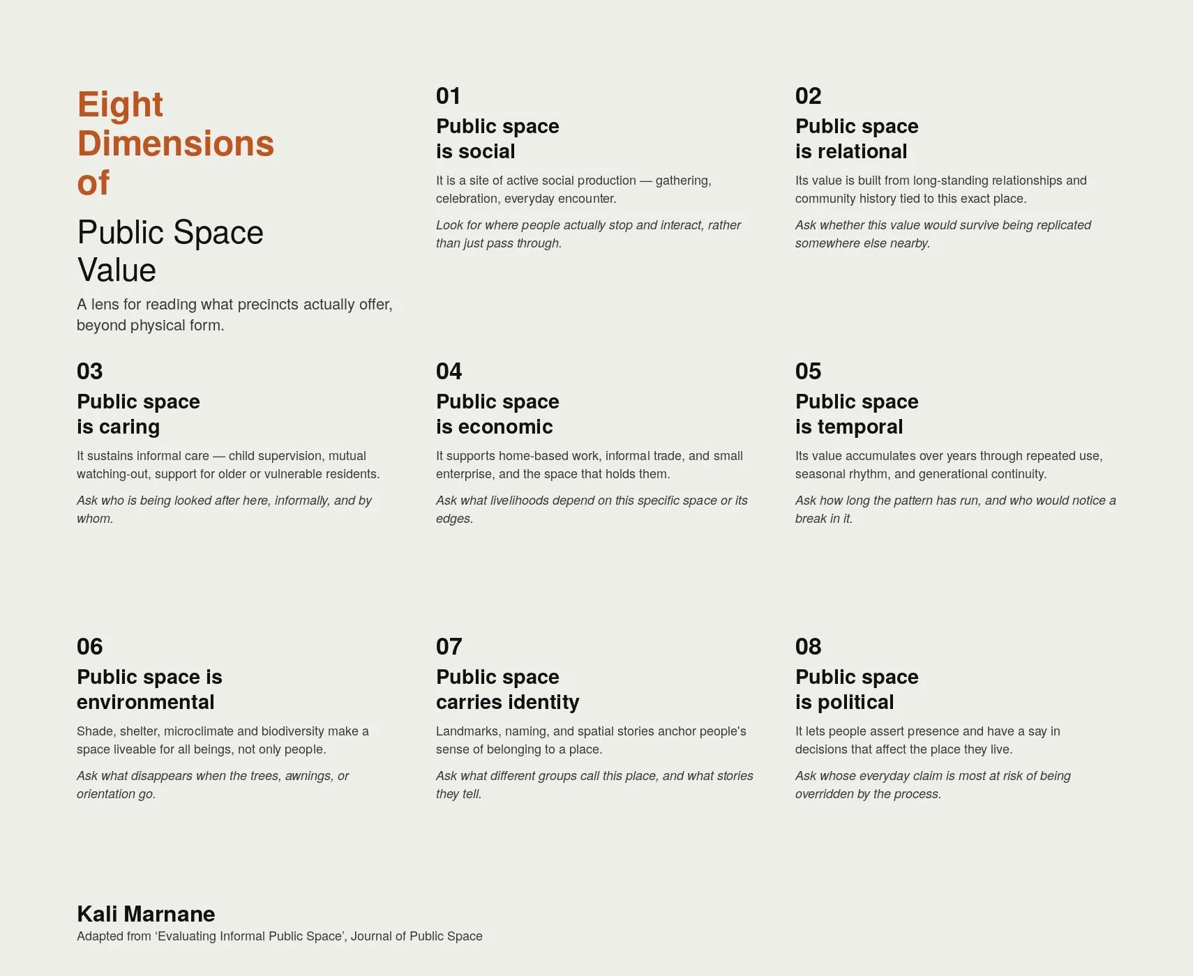
Why use this framework?
This methodology produces:
A typology of distinct space types within the precinct, defined by use and social character, not just by physical dimensions
Activity and movement data disaggregated by who is using the space
A value assessment against the eight dimensions for each space type
A clear statement of what's at risk under each proposed design option — useful directly in a design brief or options-appraisal report
The framework is most useful for:
Public housing estate renewal and precinct redevelopment
Town centre or activity centre upgrades with an existing resident or trader base
Any project where a community has history in a place and where "what's already there" is at risk of being read as a blank canvas rather than a living asset
Places in which outsiders can overlook local significance because of stigma, aesthetics, negative media image, or other aspects of marginalisation
Engagements where standard consultation (surveys, workshops) risks missing quieter, less-visible users such as older residents, carers, children, informal traders, culturally and linguistically diverse communities
It's less useful for greenfield sites with no embedded community, or infrastructural upgrades with no social dimension. Those projects require a different approach to uncover meaning (another article perhaps!).
This framework can inform decisions around:
Design: which spaces and scales must be retained, replicated, or carefully re-provided to avoid severing existing social infrastructure
Sequencing/staging: what can be temporarily lost without lasting harm, versus what cannot be interrupted even briefly (e.g. spaces central to caring or livelihood functions)
Engagement design: who needs to be reached beyond the standard consultation list, and through what means (walking, wheeling, creative activities, informal conversation) rather than formal workshops or surveys
Value case: a way of articulating social value in terms specific and evidenced enough to hold weight in a business case or planning justification, alongside conventional metrics
You can read the original methodology published by the Journal of Public Space here: https://www.journalpublicspace.org/index.php/jps/article/view/1896
Other than a word of warning that the paper linked above is highly academic with a lot of theoretical framing, it is important to note that the original methodology was developed in a context of extreme structural inequality, poverty, and the threat of demolition representing high ethical stakes and requiring more intensive elements (months of relationship-building, a full reflexive field diary) that are not proportionate to a standard consulting engagement in Australia. But the core argument is relevant in any context where an evaluation might otherwise mistake "chaotic," "unattractive," "underused" or “poor” spaces for "no one cares" or “it needs to be demolished and redeveloped” … it's usually worth checking before you believe those assumptions. They're almost always wrong.